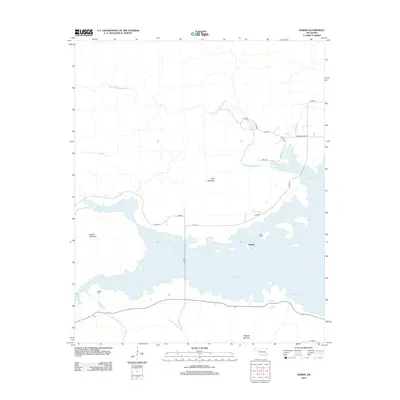
2013 Map of Sardis
USGS Topo · Published 2013About this map
Sardis Lake dominates this landscape in Pushmataha County, its waters sprawling between high ridges and defining the local geography. The settlement of Sardis sits along the northern shore, where local history is anchored by the Sardis Cem. The terrain is characterized by prominent peaks, including Wolf Mountain and Middle Mountain to the north and west, while Flagpole Mountain rises to the south. This survey illustrates how the reservoir has reshaped the valley, inundating previous creek beds while maintaining the flow of the West Fork Anderson Cr and Maxwell Cr into the basin. To the southwest, the Borden Cem remains a notable landmark above the waterline, providing a touchstone for genealogical research in this part of Oklahoma. The road network, including Co RD 1615 and n4260 RD, traces the shoreline and connects the isolated points of elevation that overlook the water.
Find a feature on this map
25 named features on this map. Tap any name to fly to it.
Don’t see what you’re looking for? This feature index may not catch every label — zoom into the map to look around manually.
Map Details
Editions of this 2013 Sardis Map
This is the sole edition of this map. No revisions or reprints were ever made.
Other maps of this area

1898 · McAlester
USGS Topo · 1:125,000

1901 · Tuskahoma
USGS Topo · 1:125,000

1908 · Tuskahoma
USGS Topo · 1:125,000

1909 · Mc Alester
USGS Topo · 1:125,000

1909 · Tuskahoma
USGS Topo · 1:125,000

1950 · Mcalester
USGS Topo · 1:250,000

1962 · McAlester
USGS Topo · 1:250,000

1965 · McAlester
USGS Topo · 1:250,000

1967 · Hartshorne
USGS Topo · 1:24,000

1971 · Yanush
USGS Topo · 1:24,000