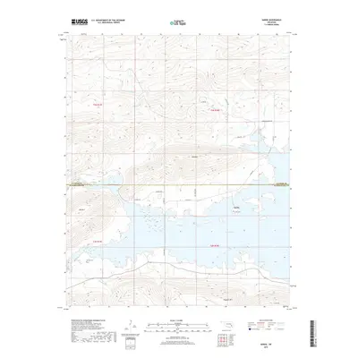
2019 Map of Sardis
USGS Topo · Published 2019About this map
Sardis Lake dominates the central landscape of this section of the Kiamichi Mountains, where the waters submerge much of the historical valley floor. The settlement of Sardis remains perched on the northern shore of the reservoir, serving as a focal point for a region defined by high ridges and narrow creek drainages. To the south, the terrain rises sharply toward Flagpole Mtn, while Mid Mtn and Wolf Mtn frame the northern reaches of the quadrangle. Local genealogy is anchored by the Sardis Cem and the more remote Borden Cem to the southwest. The map details a network of rural routes such as the Savage Hwy and Co RD 4260 that connect these upland communities. Tributaries like W Fork Anderson Cr and Maxwell Cr illustrate the complex drainage patterns that feed into the larger reservoir system.
Find a feature on this map
28 named features on this map. Tap any name to fly to it.
Don’t see what you’re looking for? This feature index may not catch every label — zoom into the map to look around manually.
Map Details
Editions of this 2019 Sardis Map
This is the sole edition of this map. No revisions or reprints were ever made.
Other maps of this area

1898 · McAlester
USGS Topo · 1:125,000

1901 · Tuskahoma
USGS Topo · 1:125,000

1908 · Tuskahoma
USGS Topo · 1:125,000

1909 · Mc Alester
USGS Topo · 1:125,000

1909 · Tuskahoma
USGS Topo · 1:125,000

1950 · Mcalester
USGS Topo · 1:250,000

1962 · McAlester
USGS Topo · 1:250,000

1965 · McAlester
USGS Topo · 1:250,000

1967 · Hartshorne
USGS Topo · 1:24,000

1971 · Yanush
USGS Topo · 1:24,000