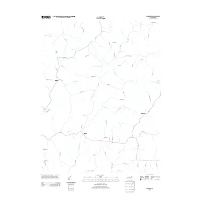
2013 Map of Sardis
USGS Topo · Published 2013About this map
Sardis and the surrounding Kentucky countryside are defined by a network of creeks and branches that feed toward the N Fork Licking River. This 2013 survey reveals a landscape largely shaped by its hydrology and ridge-top transit, with routes like Opossum Ridge Rd and Ogden Ridge following the natural high ground between drainage basins. The settlement of Abigail sits in the northwest near Whippoorwill Br, while Shannon occupies the eastern portion of the map along Shannon Cr. Local history and family genealogy are reflected in the numerous named thoroughfares such as Mastins Mill, Forman Chapel Rd, and Swartz Ln. The drainage patterns of Five Lick Cr and Panther Cr illustrate the dissected topography typical of the region, where roads and small settlements follow the meandering paths of the water and the rising terrain of the ridges.
Find a feature on this map
65 named features on this map. Tap any name to fly to it.
Don’t see what you’re looking for? This feature index may not catch every label — zoom into the map to look around manually.
Map Details
Editions of this 2013 Sardis Map
This is the sole edition of this map. No revisions or reprints were ever made.
Other maps of this area

1915 · Maysville
USGS Topo · 1:62,500

1919 · Maysville
USGS Topo · 1:62,500

1952 · Cowan
USGS Topo · 1:24,000

1952 · Germantown
USGS Topo · 1:24,000

1952 · Elizaville
USGS Topo · 1:24,000

1952 · Maysville West
USGS Topo · 1:24,000

1952 · Sardis
USGS Topo · 1:24,000

1952 · Mount Olivet
USGS Topo · 1:24,000

1952 · Piqua
USGS Topo · 1:24,000
1952 · Mays Lick
USGS Topo · 1:24,000