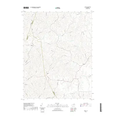
2019 Map of Sardis
USGS Topo · Published 2019About this map
Sardis and the surrounding borderlands of Bracken, Mason, and Robertson counties are defined by the winding course of the N Fork Licking River. This 2019 survey captures a landscape of high ridges and deep creek hollows, where local life follows the contours of the terrain along historical routes like Three Lick Pike and Old Sardis Pike. Small settlements such as Abigail and Shannon serve as anchor points for rural residency, while family-named roads and landmarks like Middleton Hill reflect generations of local history. The drainage network is particularly dense here, with dozens of named branches such as Panther Cr, Two Lick Cr, and Blue Lick Cr feeding into the river system. This modern topographic study preserves the naming conventions and land divisions of this Kentucky interior before further development or consolidation.
Find a feature on this map
64 named features on this map. Tap any name to fly to it.
Don’t see what you’re looking for? This feature index may not catch every label — zoom into the map to look around manually.
Map Details
Editions of this 2019 Sardis Map
This is the sole edition of this map. No revisions or reprints were ever made.
Other maps of this area

1915 · Maysville
USGS Topo · 1:62,500

1919 · Maysville
USGS Topo · 1:62,500

1952 · Cowan
USGS Topo · 1:24,000

1952 · Germantown
USGS Topo · 1:24,000

1952 · Elizaville
USGS Topo · 1:24,000

1952 · Maysville West
USGS Topo · 1:24,000

1952 · Sardis
USGS Topo · 1:24,000

1952 · Mount Olivet
USGS Topo · 1:24,000

1952 · Piqua
USGS Topo · 1:24,000
1952 · Mays Lick
USGS Topo · 1:24,000