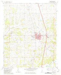
1982 Map of Sardis
USGS Topo · Published 1982About this map
Sardis serves as the focal point for this early 1980s Panola County study, centered on the intersection of the Illinois Central Gulf railroad and local infrastructure. The town's layout is documented in detail, featuring the City Hall, North County Hospital, and Lincoln Park. The surrounding landscape is defined by the hydrologic network of the Little Tallahatchie River and its numerous tributaries, including North Fork Bear Creek and South Fork Bear Creek.
Find a feature on this map
45 named features on this map. Tap any name to fly to it.
Don’t see what you’re looking for? This feature index may not catch every label — zoom into the map to look around manually.
Map Details
Editions of this 1982 Sardis Map
This is the sole edition of this map. No revisions or reprints were ever made.
Other maps of this area

1932 · Sledge
USGS Topo · 1:48,000

1932 · Crenshaw
USGS Topo · 1:62,500

1935 · Crenshaw
USGS Topo · 1:62,500

1935 · Sledge
USGS Topo · 1:62,500

1939 · Sledge
USGS Topo · 1:62,500

1944 · Senatobia
USGS Topo · 1:62,500

1948 · Helena
USGS Topo · 1:250,000

1950 · Helena
USGS Topo · 1:250,000

1952 · Sardis
USGS Topo · 1:62,500

1953 · Sardis
USGS Topo · 1:62,500