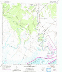
1952 Map of Sargent
USGS Topo · Published 1991About this map
Caney Creek meanders sharply toward the coast in this detailed study of the Texas shoreline, where the community of Sargent sits as a vital link between the mainland and the marsh. The landscape is defined by the winding hydrology of Live Oak Bayou and Boggy Bayou, which feed into the expansive East Matagorda Bay. The map captures a moment when the regional economy was anchored by local extraction and transit, evidenced by several Oil Wells and Oil Tanks situated near the waterway.
Find a feature on this map
22 named features on this map. Tap any name to fly to it.
Don’t see what you’re looking for? This feature index may not catch every label — zoom into the map to look around manually.
Map Details
Editions of this 1952 Sargent Map
4 editions found
Other maps of this area

1951 · Bay City
USGS Topo · 1:250,000

1952 · Lake Austin
USGS Topo · 1:24,000

1952 · Cedar Lane NE
USGS Topo · 1:24,000

1952 · Dressing Point
USGS Topo · 1:24,000

1952 · Cedar Lakes West
USGS Topo · 1:24,000
1952 · Brown Cedar Cut
USGS Topo · 1:24,000

1952 · Bay City NE
USGS Topo · 1:24,000

1952 · Cedar Lane
USGS Topo · 1:24,000

1952 · Sargent
USGS Topo · 1:24,000

1956 · Bay City
USGS Topo · 1:250,000