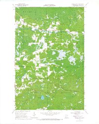
1964 Map of Sassas Creek
USGS Topo · Published 1966About this map
Superior National Forest and Koochiching State Forest dominate this north-woods landscape, where the confluence of several waterways defines the local geography. The winding Little Fork River cuts through the northern sections of Beatty and Owens, while the Sturgeon River and Rice River converge in the southwest near the Angora boundary. The terrain is a complex network of wetlands and wooded lowlands typical of St. Louis County, punctuated by several Gravel Pits that suggest local road-building or industrial activity during the mid-1960s. Central to the southern portion of the sheet are the waters of Big Rosendahl Lake and Rosendahl Lake, providing a clear focal point for those studying the hydrologic patterns and land use within the national forest boundaries of this era.
Find a feature on this map
16 named features on this map. Tap any name to fly to it.
Don’t see what you’re looking for? This feature index may not catch every label — zoom into the map to look around manually.
Map Details
Editions of this 1964 Sassas Creek Map
3 editions found
Other maps of this area

1950 · Biwabik NW
USGS Topo · 1:24,000

1951 · Biwabik NW
USGS Topo · 1:24,000

1951 · Britt
USGS Topo · 1:24,000

1952 · Idington
USGS Topo · 1:24,000

1954 · Hibbing
USGS Topo · 1:250,000

1956 · Vermilion Dam
USGS Topo · 1:24,000

1956 · Lost Lake
USGS Topo · 1:24,000

1957 · Hibbing
USGS Topo · 1:250,000

1958 · Hibbing
USGS Topo · 1:250,000

1964 · Hibbing
USGS Topo · 1:250,000