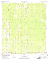
1980 Map of Satsuma
USGS Topo · Published 1981About this map
Satsuma and the surrounding piney woods of Livingston Parish are defined by a complex network of waterways, including Middle Colyell Creek, Hornsby Creek, and Hog Branch. The landscape is dotted with several family-named landmarks and rural congregations that reveal the social fabric of the era. Genealogists will find particular value in the numerous burial grounds such as Salem Cem, Lanier Cem, and the S Stafford Cem located near the Illinois Central Gulf Railroad Grade.
Find a feature on this map
27 named features on this map. Tap any name to fly to it.
Don’t see what you’re looking for? This feature index may not catch every label — zoom into the map to look around manually.
Map Details
Editions of this 1980 Satsuma Map
This is the sole edition of this map. No revisions or reprints were ever made.
Other maps of this area

1934 · Denham Springs
USGS Topo · 1:62,500

1934 · Springfield
USGS Topo · 1:62,500

1939 · Springfield
USGS Topo · 1:62,500

1939 · Denham Springs
USGS Topo · 1:62,500

1942 · Montpelier
USGS Topo · 1:31,680

1942 · Pine Grove
USGS Topo · 1:31,680

1942 · Pride
USGS Topo · 1:31,680

1942 · Watson
USGS Topo · 1:31,680

1942 · Satsuma
USGS Topo · 1:31,680

1950 · Doyle
USGS Topo · 1:31,680