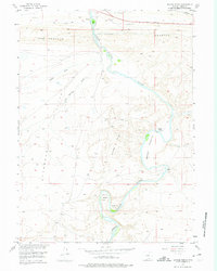
1955 Map of Savage Ranch
USGS Topo · Published 1975About this map
North Platte River waters wind through this high-altitude landscape in Carbon County, where ranching and early highway travel define the mid-century environment. The map details the transition from the Hogback and Severon ridges down to the fertile Savage Meadows. Human activity is centered on isolated outposts such as Savage Ranch and the curiously named The Old Bob Place near Oxbow Bend.
Find a feature on this map
17 named features on this map. Tap any name to fly to it.
Don’t see what you’re looking for? This feature index may not catch every label — zoom into the map to look around manually.
Map Details
Editions of this 1955 Savage Ranch Map
3 editions found
Other maps of this area

1893 · Fort Steele
USGS Topo · 1:125,000

1914 · Walcott
USGS Topo · 1:62,500

1953 · Sinclair
USGS Topo · 1:24,000

1954 · Rawlins
USGS Topo · 1:250,000

1955 · Overland
USGS Topo · 1:24,000

1955 · Overland Crossing
USGS Topo · 1:24,000

1955 · Meads
USGS Topo · 1:24,000

1955 · Savage Ranch
USGS Topo · 1:24,000

1956 · Bolten Ranch
USGS Topo · 1:62,500

1958 · Rawlins
USGS Topo · 1:250,000