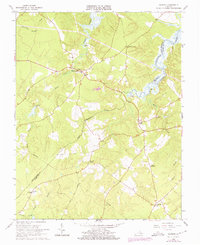
1966 Map of Savedge
USGS Topo · Published 1975About this map
Upper Chippokes Creek snakes through this rural landscape on the border of Prince George and Surry counties, serving as a primary drainage for the surrounding marshlands and timbered ridges. The settlement pattern in the mid-1960s remained focused around long-standing crossroads such as Burrowsville and Cabin Point, where small clusters of homes and community buildings formed the social hubs of a largely agricultural economy. The interior is marked by several traditional houses of worship, including Salem Ch and the Church of All Nations, alongside family-named landmarks like Taylors Corner. Notable for local historians is the site of Lone Oak Mill along the Wards Creek drainage, a remnant of the region's water-powered past. To the south, the terrain descends into the low-lying Otterdam Swamp near Barham, illustrating the transition from the upland farms to the tidal flats along the James River tributaries.
Find a feature on this map
27 named features on this map. Tap any name to fly to it.
Don’t see what you’re looking for? This feature index may not catch every label — zoom into the map to look around manually.
Map Details
Editions of this 1966 Savedge Map
2 editions found
Other maps of this area

1917 · Toano
USGS Topo · 1:62,500

1918 · Charles City
USGS Topo · 1:62,500

1918 · Toano
USGS Topo · 1:62,500

1919 · Surry
USGS Topo · 1:62,500

1919 · Disputanta
USGS Topo · 1:62,500

1943 · Savedge
USGS Topo · 1:31,680

1943 · Disputanta
USGS Topo · 1:31,680

1943 · Richmond
USGS Topo · 1:250,000

1944 · Waverly
USGS Topo · 1:31,680
1944 · Nebletts Mill
USGS Topo · 1:31,680