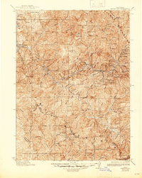
1923 Map of Sawyers Bar
USGS Topo · Published 1945About this map
The North Fork Salmon River and South Fork Salmon River converge in this rugged section of the Klamath National Forest, where the lode mining era of the early twentieth century is still in full swing. Local industry is anchored by extensive operations such as the Forks of Salmon Mining Co and a dense network of claims including the King Solomon Mine, Black Bear Mine, and Bloomer Mines. Remote mountain life is evidenced by small outposts like Sawyers Bar and Cecilville, supported by a scattering of local institutions including the Russianville School and Somes Bar School. This 1913-era topography documents the complex human footprint in the Salmon Mountains during a period of heavy mineral extraction, tracing old pack trails and ranch sites like Edie Ranch and Godfreys Ranch that once connected these isolated mining camps.
Find a feature on this map
125 named features on this map. Tap any name to fly to it.
Don’t see what you’re looking for? This feature index may not catch every label — zoom into the map to look around manually.
Map Details
Editions of this 1923 Sawyers Bar Map
4 editions found

Other maps of this area

1886 · Shasta
USGS Topo · 1:250,000

1890 · Red Bluff
USGS Topo · 1:250,000

1894 · Red Bluff
USGS Topo · 1:250,000

1894 · Shasta
USGS Topo · 1:250,000

1901 · Redding
USGS Topo · 1:125,000

1909 · Big Bar
USGS Topo · 1:96,000

1913 · Weaverville
USGS Topo · 1:125,000

1914 · Seiad
USGS Topo · 1:125,000

1915 · Big Bar and Vicinity
USGS Topo · 1:250,000

1921 · Shasta Valley Sheet No 7
USGS Topo · 1:24,000