
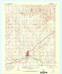
1960 Map of Sayre
USGS Topo · Published 1961About this map
The North Fork Red River snakes across this western Oklahoma landscape, defining the region's physical and economic character at the turn of the 1960s. Sayre serves as the central hub, where the Chicago Rock Island and Pacific railroad intersects with major regional thoroughfares. The transition between the high plains and the river valley is marked by a network of smaller watercourses like Sandstone Creek and Timber Creek, which supported early 20th-century agrarian settlements.
Find a feature on this map
39 named features on this map. Tap any name to fly to it.
Don’t see what you’re looking for? This feature index may not catch every label — zoom into the map to look around manually.
Map Details
Editions of this 1960 Sayre Map
2 editions found
Other maps of this area

1955 · Clinton
USGS Topo · 1:250,000

1957 · Clinton
USGS Topo · 1:250,000

1960 · Sweetwater
USGS Topo · 1:62,500

1960 · Cheyenne
USGS Topo · 1:62,500

1960 · Hammon
USGS Topo · 1:62,500

1961 · Reydon
USGS Topo · 1:62,500

1961 · Willow
USGS Topo · 1:62,500

1961 · Erick
USGS Topo · 1:62,500

1961 · Retrop
USGS Topo · 1:62,500

1961 · Elk City
USGS Topo · 1:62,500