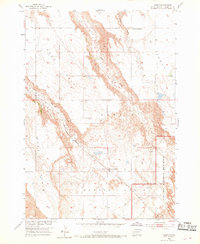
1954 Map of Scenic
USGS Topo · Published 1969About this map
Scenic Basin and its surrounding plateau systems define the landscape of this mid-century Pennington County survey. The small settlement of Scenic serves as a central hub, situated along the Chicago Milwaukee St Paul and Pacific railroad line. The topography is characterized by expansive elevated flats like Kube Table and Hart Table, which drop off into intricate drainages such as Bear Creek and Spring Draw.
Find a feature on this map
14 named features on this map. Tap any name to fly to it.
Don’t see what you’re looking for? This feature index may not catch every label — zoom into the map to look around manually.
Map Details
Editions of this 1954 Scenic Map
4 editions found
Other maps of this area

1950 · Sheep Mountain Table
USGS Topo · 1:24,000

1950 · Imlay
USGS Topo · 1:24,000

1951 · Heutmacher Table
USGS Topo · 1:24,000

1954 · Scenic
USGS Topo · 1:24,000

1954 · Creston
USGS Topo · 1:24,000

1954 · Scenic SW
USGS Topo · 1:24,000

1954 · Brennan Flat
USGS Topo · 1:24,000

1954 · Quinn Table
USGS Topo · 1:24,000

1955 · Hot Springs
USGS Topo · 1:250,000
1960 · Quinn Table SW
USGS Topo · 1:24,000