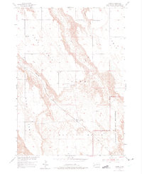
1954 Map of Scenic
USGS Topo · Published 1975About this map
Scenic serves as the primary outpost in this mid-century portrait of the Pennington County landscape, situated along the Chicago Milwaukee St Paul and Pacific railroad line. The settlement is flanked by the distinctive high plateau formations of Kube Table, 71 Table, and Hart Table, which define the region's sharp relief. Educational and community anchors like the Kube Sch and North 71 Table Sch are positioned atop these tables, reflecting a dispersed rural population reliant on these elevated plains.
Find a feature on this map
20 named features on this map. Tap any name to fly to it.
Don’t see what you’re looking for? This feature index may not catch every label — zoom into the map to look around manually.
Map Details
Editions of this 1954 Scenic Map
4 editions found
Other maps of this area

1950 · Sheep Mountain Table
USGS Topo · 1:24,000

1950 · Imlay
USGS Topo · 1:24,000

1951 · Heutmacher Table
USGS Topo · 1:24,000

1954 · Scenic
USGS Topo · 1:24,000

1954 · Creston
USGS Topo · 1:24,000

1954 · Scenic SW
USGS Topo · 1:24,000

1954 · Brennan Flat
USGS Topo · 1:24,000

1954 · Quinn Table
USGS Topo · 1:24,000

1955 · Hot Springs
USGS Topo · 1:250,000
1960 · Quinn Table SW
USGS Topo · 1:24,000