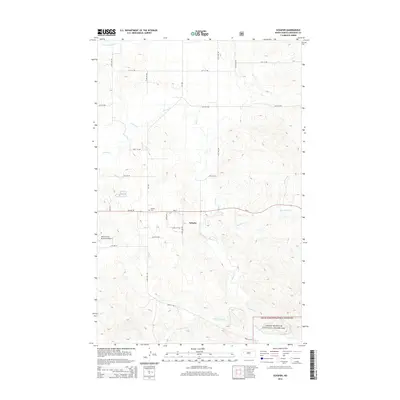
2014 Map of Schafer
USGS Topo · Published 2014About this map
Schafer sits at the heart of this North Dakota landscape, a settlement positioned along the route of ND-23. This 2014 survey documents the area just east of the growing regional center of Watford City, showing the transition from the organized grid of the town outskirts to the undulating terrain of the Badlands fringe. Significant for local historians and genealogists, the Schafer Cem is clearly marked near the townsite, preserving a physical record of the early community. The southeastern portion of the map is defined by the Little Missouri National Grassland, where the terrain becomes more complex as it descends toward the river breaks. A dense network of local routes like 31st St NW and 23rd St NW provides access to the agricultural and ranching parcels that dominate the region, while the Watford City Municipal Airport marks the western edge of the quadrangle, serving as a hub for modern transport.
Find a feature on this map
19 named features on this map. Tap any name to fly to it.
Don’t see what you’re looking for? This feature index may not catch every label — zoom into the map to look around manually.
Map Details
Editions of this 2014 Schafer Map
This is the sole edition of this map. No revisions or reprints were ever made.
Other maps of this area

1953 · Watford City
USGS Topo · 1:250,000

1957 · Watford City
USGS Topo · 1:250,000

1958 · Tepee Buttes
USGS Topo · 1:24,000

1959 · Lone Butte NW
USGS Topo · 1:24,000

1959 · Lone Butte NE
USGS Topo · 1:24,000

1967 · Watford City
USGS Topo · 1:250,000

1978 · Schafer
USGS Topo · 1:24,000

1978 · Watford City NE
USGS Topo · 1:24,000
1978 · Schafer SE
USGS Topo · 1:24,000
1978 · Watford City
USGS Topo · 1:24,000