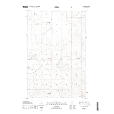
2017 Map of Schafer
USGS Topo · Published 2017About this map
Schafer sits at the heart of this McKenzie County landscape, representing a small but significant node of settlement in western North Dakota. The area's history is anchored by the Schafer Cem, a key landmark for local genealogists and historians. The terrain is defined by the drainage network of Cherry Cr, Northfork Cr, and Sevenmile Cr, which carve through the plains. To the south, the boundary of the Little Missouri National Grassland introduces a shift toward protected public lands, while the western edge of the map shows the modern infrastructure of the Watford City Municipal Airport. This 2017 survey documents the intersection of rural heritage and contemporary transportation, with local routes like Co Rd 37 and North St connecting the scattered homesteads and section lines of the northern Great Plains.
Find a feature on this map
22 named features on this map. Tap any name to fly to it.
Don’t see what you’re looking for? This feature index may not catch every label — zoom into the map to look around manually.
Map Details
Editions of this 2017 Schafer Map
This is the sole edition of this map. No revisions or reprints were ever made.
Other maps of this area

1953 · Watford City
USGS Topo · 1:250,000

1957 · Watford City
USGS Topo · 1:250,000

1958 · Tepee Buttes
USGS Topo · 1:24,000

1959 · Lone Butte NW
USGS Topo · 1:24,000

1959 · Lone Butte NE
USGS Topo · 1:24,000

1967 · Watford City
USGS Topo · 1:250,000

1978 · Schafer
USGS Topo · 1:24,000

1978 · Watford City NE
USGS Topo · 1:24,000
1978 · Schafer SE
USGS Topo · 1:24,000
1978 · Watford City
USGS Topo · 1:24,000