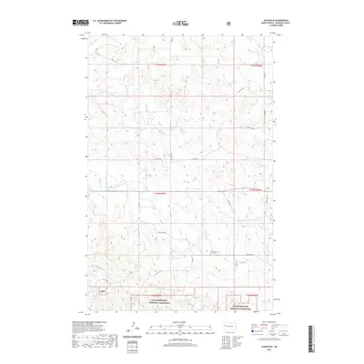
2020 Map of Schafer SE
USGS Topo · Published 2020About this map
Little Missouri National Grassland dominates the southern landscape of this McKenzie County survey, providing a snapshot of the region's managed plains. The terrain is defined by the winding course of Northfork Cr, which cuts through the township sections as it flows eastward. A significant landmark for local history and genealogy is the North Fork Trinity Cem, situated along the section lines north of Beaver Crk Rd. The map detail shows a sparse but organized network of rural routes, including Co Rte 45 and Stone Johny Rd, which follow the rigid grid of the Public Land Survey System. These roads connect isolated ranching and agricultural interests across the townships of T150N and T151N, illustrating the enduring spatial patterns of North Dakota's high plains.
Find a feature on this map
26 named features on this map. Tap any name to fly to it.
Don’t see what you’re looking for? This feature index may not catch every label — zoom into the map to look around manually.
Map Details
Editions of this 2020 Schafer SE Map
This is the sole edition of this map. No revisions or reprints were ever made.
Other maps of this area

1953 · Watford City
USGS Topo · 1:250,000

1957 · Watford City
USGS Topo · 1:250,000

1959 · Lone Butte NW
USGS Topo · 1:24,000

1959 · Croff
USGS Topo · 1:24,000

1959 · Lone Butte NE
USGS Topo · 1:24,000

1965 · Keene
USGS Topo · 1:24,000

1965 · Johnsons Corner
USGS Topo · 1:24,000

1967 · Watford City
USGS Topo · 1:250,000

1978 · Schafer
USGS Topo · 1:24,000
1978 · Schafer SE
USGS Topo · 1:24,000