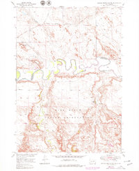
1951 Map of School Section Butte
USGS Topo · Published 1979About this map
The White River carves a deeply sinuous path through this Dakota landscape, marking the northern reaches of the Pine Ridge Indian Reservation. The terrain is characterized by high, flat-topped overlooks such as School Section Butte and Flat Top Butte, providing a clear view of the complex drainage network including Sixteenmile Creek and Bear-in-the-Lodge Creek. At the time of this 1948 aerial survey, the northern edge of the map follows the corridor of the Chicago Milwaukee St Paul and Pacific railroad, which historically linked the small ranching outposts of the interior to larger markets. Land use in this era appears centered on the river bottoms and scattered points of development like the Craven Ranch, where a Spring provides a vital water source in the arid breaks of the Eagle Nest Creek drainage.
Find a feature on this map
12 named features on this map. Tap any name to fly to it.
Don’t see what you’re looking for? This feature index may not catch every label — zoom into the map to look around manually.
Map Details
Editions of this 1951 School Section Butte Map
2 editions found
Other maps of this area

1950 · Interior
USGS Topo · 1:24,000

1950 · Interior SE
USGS Topo · 1:24,000

1950 · Potato Creek
USGS Topo · 1:24,000

1950 · Wanblee
USGS Topo · 1:24,000

1950 · Weta
USGS Topo · 1:24,000

1951 · Wanblee NW
USGS Topo · 1:24,000

1951 · School Section Butte
USGS Topo · 1:24,000

1955 · Martin
USGS Topo · 1:250,000

1958 · Martin
USGS Topo · 1:250,000

1960 · Cottonwood SW
USGS Topo · 1:24,000