
1969 Map of Schramm
USGS Topo · Published 1972About this map
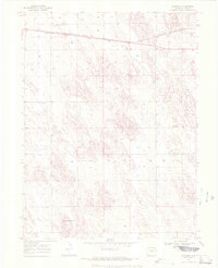
Burlington Northern rails cut across the northern plains of Yuma County in this 1969 survey, where the small settlement of Schramm sits near prominent Storage Bins. The landscape is defined by the agricultural and extractive needs of the High Plains, evidenced by the numerous Well sites and a Gravel Pit located along the rail corridor. Further south, the terrain rises toward Mount Yuma, a notable local landmark near the Pletcher area. This map illustrates the intersection of industrial transport and rural land management, with the Base Line survey mark anchoring the southern boundary. The topography reveals the subtle drainage patterns and depressions characteristic of this part of eastern Colorado, offering a clear view of the area's development before modern shifts in regional infrastructure.
Find a feature on this map
9 named features on this map. Tap any name to fly to it.
Don’t see what you’re looking for? This feature index may not catch every label — zoom into the map to look around manually.
Map Details
Editions of this 1969 Schramm Map
3 editions found
Other maps of this area

1954 · Limon
USGS Topo · 1:250,000

1954 · Sterling
USGS Topo · 1:250,000

1957 · Limon
USGS Topo · 1:250,000

1958 · Limon
USGS Topo · 1:250,000

1958 · Sterling
USGS Topo · 1:250,000

1961 · Eckley
USGS Topo · 1:24,000

1969 · Heartstrong
USGS Topo · 1:24,000

1969 · Vernon NW
USGS Topo · 1:24,000

1971 · Yuma NE
USGS Topo · 1:24,000
1971 · Eckley NW
USGS Topo · 1:24,000