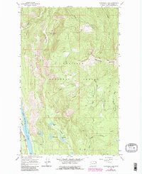
1967 Map of Scotchman Lake
USGS Topo · Published 1986About this map
Colville National Forest dominates this northeastern Washington landscape, where the Pend Oreille River flows along the western edge of the quadrangle. The map captures a transition from the river valley to the high peaks of Molybdenum Mountain and Hanlon Mtn. A network of small alpine lakes is scattered throughout the drainages, including Scotchman Lake, Anderson Lake, and the secluded Deception Lake. Deep geological depressions like Dry Canyon and prominent rises such as Coyote Hill define the interior terrain. Significant water systems, notably the West Branch Le Clerc Creek and its many tributaries like Tioga Creek and White Man Creek, illustrate the complex drainage patterns of the Selkirk Mountains. The presence of numerous Jeep Trails provides evidence of the forest's utility for land management and recreation during the mid-to-late twentieth century.
Find a feature on this map
24 named features on this map. Tap any name to fly to it.
Don’t see what you’re looking for? This feature index may not catch every label — zoom into the map to look around manually.
Map Details
Editions of this 1967 Scotchman Lake Map
3 editions found
Other maps of this area

1934 · Metaline
USGS Topo · 1:125,000

1942 · Metaline
USGS Topo · 1:125,000

1958 · Sandpoint
USGS Topo · 1:250,000

1963 · Sandpoint
USGS Topo · 1:250,000

1967 · Timber Mtn.
USGS Topo · 1:24,000

1967 · Ione
USGS Topo · 1:24,000

1967 · Scotchman Lake
USGS Topo · 1:24,000

1967 · Metaline
USGS Topo · 1:24,000

1967 · Metaline Falls
USGS Topo · 1:24,000

1967 · Monumental Mtn.
USGS Topo · 1:24,000