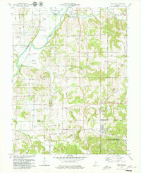
1979 Map of Scotland
USGS Topo · Published 1979About this map
The White River flows along the western edge of this 1970s landscape, bordering the rich lowlands of Bogard Bottoms. This era in southwestern Indiana is marked by a blend of agricultural tradition and federal defense operations, as the eastern portion of the quadrangle is occupied by the U S Naval Reservation Weapons Support Center. Significant rural infrastructure remains visible, such as a Covered Bridge spanning Plummer Creek near the settlement of Mineral City.
Find a feature on this map
80 named features on this map. Tap any name to fly to it.
Don’t see what you’re looking for? This feature index may not catch every label — zoom into the map to look around manually.
Map Details
Editions of this 1979 Scotland Map
Other maps of this area

1908 · Bloomfield
USGS Topo · 1:62,500

1938 · Switz City
USGS Topo · 1:24,000

1943 · Lyons
USGS Topo · 1:24,000

1943 · Epsom
USGS Topo · 1:24,000

1947 · Switz City
USGS Topo · 1:24,000

1950 · Switz City
USGS Topo · 1:24,000

1950 · Odon
USGS Topo · 1:24,000

1951 · Bloomfield
USGS Topo · 1:24,000

1953 · Indianapolis
USGS Topo · 1:250,000

1956 · Indianapolis
USGS Topo · 1:250,000