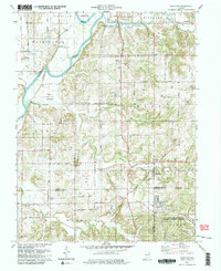
1979 Map of Scotland
USGS Topo · Published 1979About this map
The White River and its major tributary, Plummer Creek, define the topography of this Greene County landscape, where the flatlands of Bogard Bottoms meet the rising terrain of Brinegar Ridge. In the southern portion of the quadrangle, the massive U S Naval Reservation Weapons Support Center occupies a significant footprint, including the area around Crane. This late 1970s survey documents a rural economy of oil wells and scattered farmsteads connected by a grid of numbered roads like 1650 North Road. Cultural landmarks are numerous, including a historic Covered Bridge near Mineral City and a local Drive-in Theater. Genealogists will find many family-named burial sites and congregations, such as Hicks Cem, Smith Bethel Cem, and Simpson Chapel, providing a clear record of the community's settlement patterns and established families along the Conrail rail line.
Find a feature on this map
60 named features on this map. Tap any name to fly to it.
Don’t see what you’re looking for? This feature index may not catch every label — zoom into the map to look around manually.
Map Details
Editions of this 1979 Scotland Map
Other maps of this area

1908 · Bloomfield
USGS Topo · 1:62,500

1938 · Switz City
USGS Topo · 1:24,000

1943 · Lyons
USGS Topo · 1:24,000

1943 · Epsom
USGS Topo · 1:24,000

1947 · Switz City
USGS Topo · 1:24,000

1950 · Switz City
USGS Topo · 1:24,000

1950 · Odon
USGS Topo · 1:24,000

1951 · Bloomfield
USGS Topo · 1:24,000

1953 · Indianapolis
USGS Topo · 1:250,000

1956 · Indianapolis
USGS Topo · 1:250,000