
1957 Map of Scotland
USGS Topo · Published 1959About this map
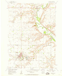
The town of Scotland serves as a local hub for this prairie landscape, where the C M St P & P railroad connects the settlement to the wider region. In the late 1950s, the community footprint included a Fairground, a local Swimming Pool, and essential civic services like the City Hall and P O. Outside the main town, the landscape is defined by the winding course of the James River and its tributaries, including Lonetree Creek and Dawson Creek.
Find a feature on this map
26 named features on this map. Tap any name to fly to it.
Don’t see what you’re looking for? This feature index may not catch every label — zoom into the map to look around manually.
Map Details
Editions of this 1957 Scotland Map
2 editions found
Other maps of this area

1898 · Olivet
USGS Topo · 1:125,000

1955 · Sioux Falls
USGS Topo · 1:250,000

1957 · Tschetter Colony
USGS Topo · 1:24,000

1957 · Menno
USGS Topo · 1:24,000

1957 · Wolf Creek
USGS Topo · 1:24,000

1958 · Sioux Falls
USGS Topo · 1:250,000

1978 · Tripp SE
USGS Topo · 1:24,000
1978 · Kloucek Lake
USGS Topo · 1:24,000
1978 · Lesterville
USGS Topo · 1:24,000
1978 · Kaylor
USGS Topo · 1:24,000