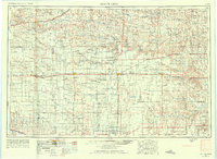
1955 Map of Scott City
USGS Topo · Published 1975About this map
Scott City serves as the central hub of this High Plains landscape, where the agricultural grid is interrupted by the winding courses of the Smoky Hill River and the Arkansas River. This mid-century view captures a network of rural education, identifying numerous local institutions such as High Prairie School and Lone Corner School that once dotted the townships. The terrain transitions from the stark Chalk Pyramids in the north to the Sand Hills south of the Arkansas, reflecting a varied geology across several Kansas counties.
Find a feature on this map
78 named features on this map. Tap any name to fly to it.
Don’t see what you’re looking for? This feature index may not catch every label — zoom into the map to look around manually.
Map Details
Editions of this 1955 Scott City Map
4 editions found

Other maps of this area

1890 · Granada
USGS Topo · 1:125,000

1891 · Albany
USGS Topo · 1:125,000

1891 · Larned
USGS Topo · 1:125,000

1892 · Ness
USGS Topo · 1:125,000

1892 · Dodge
USGS Topo · 1:125,000

1892 · Cheyenne Wells
USGS Topo · 1:125,000

1892 · Granada
USGS Topo · 1:125,000

1892 · Spearville
USGS Topo · 1:125,000

1893 · Ellis
USGS Topo · 1:125,000

1893 · Albany
USGS Topo · 1:125,000