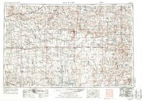
1955 Map of Scott City
USGS Topo · Published 1987About this map
Scott City sits at a crossroads of the High Plains in this mid-century Western Kansas landscape, defined by a rigid grid of section lines and a vital network of railroads. The industrial spine of the region is traced by the Union Pacific RR in the north and the Missouri Pacific RR through the center, connecting settlements like Wakeeney, Oakley, and Dighton. To the south, the Atchison Topeka and Santa Fe RR follows the Arkansas River corridor. The terrain is marked by the unique geology of the Chalk Pyramids and the drainages of Ladder Creek and the Smoky Hill River. Scattered throughout the expanse are numerous Windmills, essential for life in this arid climate, alongside early recreational sites such as Scott Co State Pk and Lane Co State Park, which highlight the preservation of water and open space during this era of agricultural development.
Find a feature on this map
97 named features on this map. Tap any name to fly to it.
Don’t see what you’re looking for? This feature index may not catch every label — zoom into the map to look around manually.
Map Details
Editions of this 1955 Scott City Map
4 editions found

Other maps of this area

1890 · Granada
USGS Topo · 1:125,000

1891 · Albany
USGS Topo · 1:125,000

1891 · Larned
USGS Topo · 1:125,000

1892 · Ness
USGS Topo · 1:125,000

1892 · Dodge
USGS Topo · 1:125,000

1892 · Cheyenne Wells
USGS Topo · 1:125,000

1892 · Granada
USGS Topo · 1:125,000

1892 · Spearville
USGS Topo · 1:125,000

1893 · Ellis
USGS Topo · 1:125,000

1893 · Albany
USGS Topo · 1:125,000