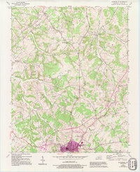
1954 Map of Scottsville
USGS Topo · Published 1995About this map
Scottsville serves as the focal point of this mid-century portrait of Allen County, situated at the intersection of a developing road network and the headwaters of the Bays Fork. The surrounding landscape is defined by the repetitive extraction of resources, with numerous Oil Wells and Oil Well sites scattered throughout the drainages of Sulphur Creek and Difficult Creek. This proliferation of small-scale energy production indicates a period of local industrial intensity that shared the land with established rural institutions.
Find a feature on this map
29 named features on this map. Tap any name to fly to it.
Don’t see what you’re looking for? This feature index may not catch every label — zoom into the map to look around manually.
Map Details
Editions of this 1954 Scottsville Map
4 editions found

Other maps of this area

1921 · Bowling Green
USGS Topo · 1:62,500

1923 · Bowling Green
USGS Topo · 1:62,500

1926 · Scottsville
USGS Topo · 1:62,500

1928 · Adolphus
USGS Topo · 1:48,000

1931 · Lafayette
USGS Topo · 1:62,500

1931 · Adolphus
USGS Topo · 1:62,500

1942 · Gallatin
USGS Topo · 1:100,000

1954 · Austin
USGS Topo · 1:24,000

1954 · Petroleum
USGS Topo · 1:24,000
1954 · Polkville
USGS Topo · 1:24,000