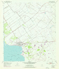
1952 Map of Seadrift
USGS Topo · Published 1976About this map
San Antonio Bay dominates the shoreline of this Calhoun County coastal area, where the settlement of Seadrift serves as the primary hub of activity. The landscape is a complex intersection of natural features and industrial engineering, defined by extensive levee systems and spoil banks that reshape the wetlands. To the north, the Long Mott Oil Field is marked by numerous oil wells, indicating the region's mid-century energy production. Local history is preserved in the presence of the Roemerville Sch and the Seadrift Cem, while the Old Railroad Grade suggests a changing transportation network. The nautical character of the region is evident through Swan Point and various Shell Reefs, which highlight the shallow, resource-rich waters vital to the local economy.
Find a feature on this map
17 named features on this map. Tap any name to fly to it.
Don’t see what you’re looking for? This feature index may not catch every label — zoom into the map to look around manually.
Map Details
Editions of this 1952 Seadrift Map
2 editions found
Other maps of this area

1952 · Port Lavaca East
USGS Topo · 1:24,000

1952 · Mosquito Point
USGS Topo · 1:24,000

1952 · Long Island
USGS Topo · 1:24,000

1952 · Tivoli SE
USGS Topo · 1:24,000

1952 · Seadrift NE
USGS Topo · 1:24,000

1952 · Austwell
USGS Topo · 1:24,000

1952 · Seadrift
USGS Topo · 1:24,000

1952 · Port Lavaca West
USGS Topo · 1:24,000

1952 · Green Lake
USGS Topo · 1:24,000

1953 · Beeville
USGS Topo · 1:250,000