
1984 Map of Seaford
USGS Topo · Published 1986About this map
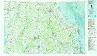
The Nanticoke River and its tributaries define the drainage of this coastal plain landscape in the mid-1980s, where the agricultural interior of Delaware and Maryland meets the developing Atlantic shoreline. This survey captures the region just as the coastal tourism economy was intensifying, contrasting the established poultry and farming centers of Seaford and Georgetown with the growing resort communities of Rehoboth Beach and Dewey Beach. Significant conservation areas, such as Prime Hook National Wildlife Refuge and the dense Cypress Swamp, illustrate the preservation of the Delmarva Peninsula's native wetlands amidst a network of state highways like U.S. 13 and the Conrail line. The map reveals the intricate water systems of the interior, featuring numerous millponds like Trap Pond and Records Pond, which provided early industrial power and later recreational anchors for the region's inland towns.
Find a feature on this map
182 named features on this map. Tap any name to fly to it.
Don’t see what you’re looking for? This feature index may not catch every label — zoom into the map to look around manually.
Map Details
Editions of this 1984 Seaford Map
2 editions found
Other maps of this area

1888 · Cape May
USGS Topo · 1:62,500

1888 · Dennisville
USGS Topo · 1:62,500

1890 · Maurice Cove
USGS Topo · 1:62,500

1891 · Maurice Cove
USGS Topo · 1:62,500

1893 · Cape May
USGS Topo · 1:62,500

1894 · Dennisville
USGS Topo · 1:62,500

1898 · Choptank
USGS Topo · 1:125,000

1898 · Tolchester
USGS Topo · 1:125,000

1898 · St. Marys
USGS Topo · 1:125,000

1898 · Cape May
USGS Topo · 1:62,500