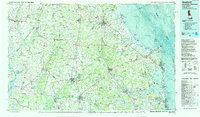
1984 Map of Seaford
USGS Topo · Published 1988About this map
Cape Henlopen and the intricate shoals of the Delaware Bay anchor this mid-1980s topographic study of the Delmarva Peninsula. The map reveals a landscape defined by its coastal marshes and an extensive network of inland waterways, including the Choptank River, Nanticoke River, and Indian River. While the Atlantic coast is dominated by Cape Henlopen State Park and the Rehoboth Bay, the interior is a mix of small settlements and managed lands like Redden State Forest and Prime Hook National Wildlife Refuge. Regional connectivity is highlighted by the Conrail lines and highway arteries like Us 13. Notable historical and military landmarks appear across the terrain, from the site of Fort Saulsbury near the coast to aviation nodes like Ridgelys Pelican Airport. Small crossroads communities such as East New Market and Oakland illustrate the persistent settlement patterns of Sussex, Caroline, and Dorchester counties.
Find a feature on this map
251 named features on this map. Tap any name to fly to it.
Don’t see what you’re looking for? This feature index may not catch every label — zoom into the map to look around manually.
Map Details
Editions of this 1984 Seaford Map
2 editions found
Other maps of this area

1888 · Cape May
USGS Topo · 1:62,500

1888 · Dennisville
USGS Topo · 1:62,500

1890 · Maurice Cove
USGS Topo · 1:62,500

1891 · Maurice Cove
USGS Topo · 1:62,500

1893 · Cape May
USGS Topo · 1:62,500

1894 · Dennisville
USGS Topo · 1:62,500

1898 · Choptank
USGS Topo · 1:125,000

1898 · Tolchester
USGS Topo · 1:125,000

1898 · St. Marys
USGS Topo · 1:125,000

1898 · Cape May
USGS Topo · 1:62,500