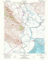
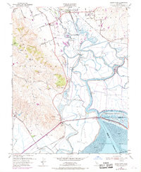
1951 Map of Sears Point
USGS Topo · Published 1974About this map
Sonoma Valley meets the marshlands of northern San Pablo Bay in this mid-century topographic record, where the intricate hydrology of the Sonoma Creek delta dominates the landscape. The area is defined by a network of engineered levees and sloughs, such as Steamboat Slough and Second Napa Slough, which weave through Tubbs Island and the neighboring Naval Reservation. These waterways supported a unique river-and-rail economy, evidenced by the Northwestern Pacific Railroad connecting small riverside outposts and agricultural camps.
Find a feature on this map
57 named features on this map. Tap any name to fly to it.
Don’t see what you’re looking for? This feature index may not catch every label — zoom into the map to look around manually.
Map Details
Editions of this 1951 Sears Point Map
5 editions found
Other maps of this area

1902 · Napa
USGS Topo · 1:125,000

1914 · Petaluma
USGS Topo · 1:62,500

1916 · Mare Island
USGS Topo · 1:62,500

1916 · Santa Rosa
USGS Topo · 1:62,500

1942 · Mare Island
USGS Topo · 1:62,500

1942 · Sonoma
USGS Topo · 1:62,500

1942 · Petaluma
USGS Topo · 1:62,500

1944 · Santa Rosa
USGS Topo · 1:62,500

1947 · Santa Rosa
USGS Topo · 1:250,000

1949 · Santa Rosa
USGS Topo · 1:250,000