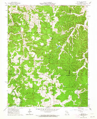
1963 Map of Seaton
USGS Topo · Published 1964About this map
Seaton and the surrounding rural landscape of the Ozarks are captured here in the early 1960s, a period where traditional land use meets the remnants of older industrial infrastructure. The map reveals a high density of local landmarks significant to genealogists, including Asher Cem, Bell Cem, Morrison Cem, and Freeman Cem. These sites, along with Highland Ch and Hale Sch, point to the dispersed community hubs that defined the area's social geography.
Find a feature on this map
26 named features on this map. Tap any name to fly to it.
Don’t see what you’re looking for? This feature index may not catch every label — zoom into the map to look around manually.
Map Details
Editions of this 1963 Seaton Map
3 editions found
Other maps of this area

1928 · Meramec Spring
USGS Topo · 1:62,500

1932 · Steelville
USGS Topo · 1:48,000

1933 · Steelville
USGS Topo · 1:62,500

1937 · Steelville
USGS Topo · 1:62,500

1941 · Salem
USGS Topo · 1:62,500

1941 · Stone Hill
USGS Topo · 1:62,500

1945 · Salem
USGS Topo · 1:62,500

1945 · Stone Hill
USGS Topo · 1:62,500

1949 · Rolla
USGS Topo · 1:250,000

1949 · Meramec Spring
USGS Topo · 1:62,500