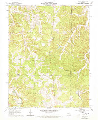
1963 Map of Seaton
USGS Topo · Published 1973About this map
Seaton and Winkler anchor this rural landscape in the early 1960s, a region defined by the headwaters of Norman Creek and the branching drainages of the DRY Fork. The map documents a significant shift in transportation, showing both the active St Louis-San Francisco railroad in the south and an abandoned Old Railroad Grade further north. This shift from rail dependency is mirrored in the distribution of community landmarks, including the Highland Ch and multiple family-named burial grounds like Asher Cem and Bell Cem. Small-scale mining operations are noted near Clinton, while the proximity of Hale Sch and Morrison Cem reflects a decentralized settlement pattern typical of the Missouri Ozarks. The terrain is marked by prominent high points such as Blue Knob, which overlooks the winding paths of Benton Creek and its many forks.
Find a feature on this map
31 named features on this map. Tap any name to fly to it.
Don’t see what you’re looking for? This feature index may not catch every label — zoom into the map to look around manually.
Map Details
Editions of this 1963 Seaton Map
3 editions found
Other maps of this area

1928 · Meramec Spring
USGS Topo · 1:62,500

1932 · Steelville
USGS Topo · 1:48,000

1933 · Steelville
USGS Topo · 1:62,500

1937 · Steelville
USGS Topo · 1:62,500

1941 · Salem
USGS Topo · 1:62,500

1941 · Stone Hill
USGS Topo · 1:62,500

1945 · Salem
USGS Topo · 1:62,500

1945 · Stone Hill
USGS Topo · 1:62,500

1949 · Rolla
USGS Topo · 1:250,000

1949 · Meramec Spring
USGS Topo · 1:62,500