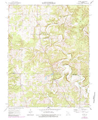
1963 Map of Lecoma
USGS Topo · Published 1985About this map
Lecoma serves as a central point of settlement in this Ozark landscape, which is marked by a complex network of karst features and seasonal waterways. The drainage of Dry Fork and Little Dry Fork dictates the local topography, punctuated by numerous subterranean features including Shelton Cave, Lenox Cave, and McClure Cave. These limestone formations are complemented by prominent water sources like Bubbling Springs, Lake Spring, and Wilson Spring, illustrating the hydrologic character of the Phelps and Dent County border region.
Find a feature on this map
36 named features on this map. Tap any name to fly to it.
Don’t see what you’re looking for? This feature index may not catch every label — zoom into the map to look around manually.
Map Details
Editions of this 1963 Lecoma Map
2 editions found
Other maps of this area

1912 · Rolla
USGS Topo · 1:62,500

1928 · Meramec Spring
USGS Topo · 1:62,500

1937 · Edgar Springs
USGS Topo · 1:48,000

1941 · Salem
USGS Topo · 1:62,500

1945 · Salem
USGS Topo · 1:62,500

1945 · Edgar Springs
USGS Topo · 1:62,500

1949 · Rolla
USGS Topo · 1:250,000

1949 · Meramec Spring
USGS Topo · 1:62,500
1950 · Yancy Mills
USGS Topo · 1:24,000
1951 · Yancy Mills
USGS Topo · 1:24,000