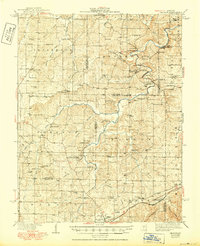
1938 Map of Redbird
USGS Topo · Published 1950About this map
The Bourbeuse River and Dry Fork carve through this Ozark landscape, defining a region where early 20th-century agriculture and industry met. In the southern reach, St James serves as a primary hub, anchored by the St James Hospital and the Soldiers Home, while the St Louis San Francisco railroad connects the town to the vineyard-dotted settlement of Rosati. The map reveals a high density of rural infrastructure, from the Stockton Mine in the north to numerous small school districts such as Jake Prairie Sch and Oak Forest Sch. Genealogists will find an extensive network of family and community burial grounds, including Pinnell Cem, Bowles Cem, and Matlock Cem. River crossings like Sewell Ford and Arthur Spring Ford illustrate the reliance on natural transit points before modern bridge development fully transformed the county line areas.
Find a feature on this map
85 named features on this map. Tap any name to fly to it.
Don’t see what you’re looking for? This feature index may not catch every label — zoom into the map to look around manually.
Map Details
Editions of this 1938 Redbird Map
3 editions found

Other maps of this area

1903 · Sullivan
USGS Topo · 1:125,000

1912 · Rolla
USGS Topo · 1:62,500

1928 · Meramec Spring
USGS Topo · 1:62,500

1932 · Steelville
USGS Topo · 1:48,000

1933 · Steelville
USGS Topo · 1:62,500

1934 · Linn
USGS Topo · 1:48,000

1934 · Bland
USGS Topo · 1:62,500

1934 · Redbird
USGS Topo · 1:62,500

1935 · Gerald
USGS Topo · 1:48,000

1937 · Bland
USGS Topo · 1:62,500