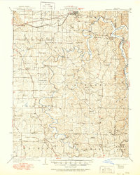
1928 Map of Meramec Spring
USGS Topo · Published 1950About this map
St James and the surrounding Ozark plateau are defined by a network of springs, deep hollows, and early industrial sites in this survey from the 1920s. The landscape is dotted with a remarkably high density of rural schoolhouses, including Flat Grove School, Zion Hill School, and Heide School, reflecting the dispersed settlement patterns of Phelps County at the time. The Meramec River and Dry Fork provide the primary drainage, with notable river crossings such as Smallwood Ford and Dean Ford serving as vital transit points before modern bridge infrastructure was fully established.
Find a feature on this map
80 named features on this map. Tap any name to fly to it.
Don’t see what you’re looking for? This feature index may not catch every label — zoom into the map to look around manually.
Map Details
Editions of this 1928 Meramec Spring Map
3 editions found
Other maps of this area

1903 · Sullivan
USGS Topo · 1:125,000

1912 · Rolla
USGS Topo · 1:62,500

1928 · Meramec Spring
USGS Topo · 1:62,500

1932 · Steelville
USGS Topo · 1:48,000

1933 · Steelville
USGS Topo · 1:62,500

1934 · Redbird
USGS Topo · 1:62,500

1937 · Steelville
USGS Topo · 1:62,500

1937 · Edgar Springs
USGS Topo · 1:48,000

1937 · Vienna
USGS Topo · 1:62,500

1938 · Redbird
USGS Topo · 1:62,500