
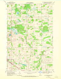
1969 Map of Sebeka NW
USGS Topo · Published 1971About this map
Runeberg and the surrounding townships of Blueberry, Paddock, and Red Eye define this rural landscape on the border of Otter Tail, Wadena, and Becker Counties. In the late 1960s, the area remained a patchwork of woodlots and drainage systems, evidenced by the prominent County Ditch No 27 cutting through the center of the sheet. Community life is anchored by local landmarks such as Runeberg Ch and Bethel Ch, alongside the White Oak Sch. The drainage of the Redeye River and Kettle River dominates the hydrology, with smaller watercourses like Kitten Creek and the marshy margins of Mud Lake shaping the local terrain. A distinct Pipeline corridor and scattered Gravel Pits reflect the modest industrial infrastructure supporting this agricultural region during the post-war era.
Find a feature on this map
24 named features on this map. Tap any name to fly to it.
Don’t see what you’re looking for? This feature index may not catch every label — zoom into the map to look around manually.
Map Details
Editions of this 1969 Sebeka NW Map
This is the sole edition of this map. No revisions or reprints were ever made.
Other maps of this area

1953 · Brainerd
USGS Topo · 1:250,000

1957 · Brainerd
USGS Topo · 1:250,000

1958 · Brainerd
USGS Topo · 1:250,000

1965 · Brainerd
USGS Topo · 1:250,000

1969 · Wolf Lake
USGS Topo · 1:24,000

1969 · Sebeka SW
USGS Topo · 1:24,000

1969 · Menahga
USGS Topo · 1:24,000

1969 · Park Rapids SW
USGS Topo · 1:24,000

1969 · Sebeka
USGS Topo · 1:24,000
1969 · New York Mills East
USGS Topo · 1:24,000