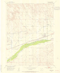
1953 Map of Sedgwick
USGS Topo · Published 1954About this map
Sedgwick serves as the focal point of this mid-century survey, situated just south of the Colorado-Nebraska State Line where the high plains meet the fertile valley of the South Platte River. The landscape is defined by an intricate network of irrigation systems essential to the regional agriculture, including the Highline Canal, Settlers Ditch, and Peterson Ditch. These man-made waterways parallel the river and the Union Pacific railroad, illustrating the intensive water management required to sustain this corner of the state.
Find a feature on this map
17 named features on this map. Tap any name to fly to it.
Don’t see what you’re looking for? This feature index may not catch every label — zoom into the map to look around manually.
Map Details
Editions of this 1953 Sedgwick Map
3 editions found
Other maps of this area

1899 · Sidney
USGS Topo · 1:125,000

1900 · Chappell
USGS Topo · 1:125,000

1952 · Julesburg SW
USGS Topo · 1:24,000

1952 · Marks Butte
USGS Topo · 1:24,000

1953 · Ovid
USGS Topo · 1:24,000

1953 · Tamarack Ranch
USGS Topo · 1:24,000

1953 · Julesburg Reservoir
USGS Topo · 1:24,000

1953 · Sedgwick
USGS Topo · 1:24,000

1954 · Sterling
USGS Topo · 1:250,000

1954 · Scottsbluff
USGS Topo · 1:250,000