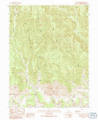
1991 Map of Sego Canyon
USGS Topo · Published 1991About this map
Sego (Site) occupies a central position within this 1991 survey, reflecting a landscape defined by industrial history and deep canyon drainage. The presence of an Adit and a Cem near the primary settlement site points to the area's mining past, while a network of 4wd tracks provides the only modern access through the intricate terrain. The map is dominated by the convergence of steep-walled systems, most notably Sego Canyon, Thompson Canyon, and Sagers Canyon.
Find a feature on this map
16 named features on this map. Tap any name to fly to it.
Don’t see what you’re looking for? This feature index may not catch every label — zoom into the map to look around manually.
Map Details
Editions of this 1991 Sego Canyon Map
This is the sole edition of this map. No revisions or reprints were ever made.
Other maps of this area

1885 · East Tavaputs
USGS Topo · 1:250,000

1885 · La Sal
USGS Topo · 1:250,000

1956 · Moab
USGS Topo · 1:250,000

1956 · Grand Junction
USGS Topo · 1:250,000

1958 · Crescent Junction
USGS Topo · 1:62,500

1958 · Thompson
USGS Topo · 1:62,500

1959 · Grand Junction
USGS Topo · 1:250,000

1959 · Moab
USGS Topo · 1:250,000

1960 · Moab
USGS Topo · 1:250,000

1960 · Grand Junction
USGS Topo · 1:250,000