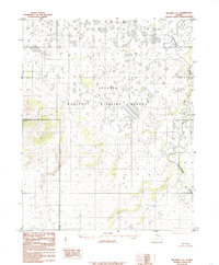
1985 Map of Selawik A-1
USGS Topo · Published 1985About this map
The Selawik National Wildlife Refuge dominates this sub-arctic landscape, providing a detailed record of the wetlands and topography as they existed in the mid-1980s. Defined by a complex network of thermokarst lakes and meandering waterways, the region's hydrology is centered on the serpentine course of the Tagagawik River, which winds through the eastern portion of the quadrangle. Compiled from 1971 aerial photography, the map documents a transition between the elevated contours of the interior and the lower marshlands typical of the Selawik Basin. The lack of any marked roads or permanent settlements emphasizes the character of this protected wilderness, where the shifting river channels and seasonal water bodies dictate the movement of people and wildlife in the Northwest Arctic.
Find a feature on this map
2 named features on this map. Tap any name to fly to it.
Don’t see what you’re looking for? This feature index may not catch every label — zoom into the map to look around manually.
Map Details
Editions of this 1985 Selawik A-1 Map
This is the sole edition of this map. No revisions or reprints were ever made.
Other maps of this area

1951 · Candle
USGS Topo · 1:250,000

1951 · Selawik
USGS Topo · 1:250,000

1951 · Shungnak
USGS Topo · 1:250,000

1951 · Kateel River
USGS Topo · 1:250,000
1954 · Candle D-1
USGS Topo · 1:63,360

1954 · Kateel River D-6
USGS Topo · 1:63,360

1954 · Candle D-2
USGS Topo · 1:63,360

1955 · Shungnak
USGS Topo · 1:250,000

1955 · Kateel River
USGS Topo · 1:250,000

1955 · Candle
USGS Topo · 1:250,000