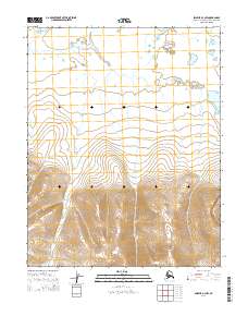
2014 Map of Selawik A-3 NW
USGS Topo · Published 2014About this map
The Kauk River winds through this expanse of the Northwest Arctic Borough, charting a serpentine course through the northern sections of the map before disappearing into the higher elevations to the south. This 2014 survey reveals a landscape largely defined by its natural drainage patterns and the stark transition from low-lying water bodies to significant upland terrain. While the northern half is characterized by the braided reaches of the river and scattered ponds, the southern half rises sharply into a series of ridges and peaks, indicated by dense contouring. This contrast illustrates the dramatic topographical shift from the river valley to the interior highlands, providing a clear view of the area's physical geography as recorded by the U.S. Geological Survey.
Find a feature on this map
9 named features on this map. Tap any name to fly to it.
Don’t see what you’re looking for? This feature index may not catch every label — zoom into the map to look around manually.
Map Details
Editions of this 2014 Selawik A-3 NW Map
This is the sole edition of this map. No revisions or reprints were ever made.
Other maps of this area

1951 · Selawik
USGS Topo · 1:250,000

1955 · Selawik A-4
USGS Topo · 1:63,360

1955 · Selawik B-3
USGS Topo · 1:63,360

1955 · Selawik A-3
USGS Topo · 1:63,360

1955 · Selawik B-4
USGS Topo · 1:63,360

1957 · Selawik
USGS Topo · 1:250,000
2014 · Selawik A-3 SW
USGS Topo · 1:25,000
2014 · Selawik A-4 SE
USGS Topo · 1:25,000

2014 · Selawik A-3 SE
USGS Topo · 1:25,000
2014 · Selawik B-4 SE
USGS Topo · 1:25,000