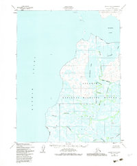
1951 Map of Selawik D-6
USGS Topo · Published 1983About this map
Hotham Inlet and the sprawling waterways of the Kobuk River Delta dominate this 1951 topographic study of the Alaskan coast. The landscape is a complex network of wetlands and interconnected water bodies, including Ekichuk Lake, Potoniek Lake, and Nulvororok Lake, all situated within what would later be designated as the Selawik National Wildlife Refuge.
Find a feature on this map
16 named features on this map. Tap any name to fly to it.
Don’t see what you’re looking for? This feature index may not catch every label — zoom into the map to look around manually.
Map Details
Editions of this 1951 Selawik D-6 Map
3 editions found
Other maps of this area

1951 · Baird Mountains
USGS Topo · 1:250,000

1951 · Selawik
USGS Topo · 1:250,000

1951 · Noatak
USGS Topo · 1:250,000

1951 · Kotzebue
USGS Topo · 1:250,000

1951 · Kotzebue D-1
USGS Topo · 1:63,360

1951 · Selawik C-6
USGS Topo · 1:63,360

1951 · Selawik D-6
USGS Topo · 1:63,360
1951 · Kotzebue C-1
USGS Topo · 1:63,360

1952 · Selawik D-6
USGS Topo · 1:63,360

1955 · Noatak
USGS Topo · 1:250,000