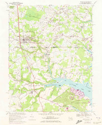
1967 Map of Selbyville
USGS Topo · Published 1973About this map
Selbyville sits at the heart of this coastal borderlands region, where the Penn Central rail line cuts south through Sussex and Worcester counties. The landscape is a complex network of agriculture and tidal waters, defined by the winding Bishopville Prong and St Martin River as they reach toward the Atlantic coast. Local life in the late 1960s is anchored by historic congregations and rural crossroads, with St Matthews Ch and Old St Martins Ch serving as longstanding community landmarks. The map also documents the early development of Ocean Pines near Jenkins Neck, contrasting new residential growth with established agricultural tracts and the American Skyways Airport. To the north, the small Delaware settlements of Roxana, Williamsville, and Bunting remain primarily rural, while the southern Maryland portion shows the importance of water access at sites like Shingle Landing.
Find a feature on this map
84 named features on this map. Tap any name to fly to it.
Don’t see what you’re looking for? This feature index may not catch every label — zoom into the map to look around manually.
Map Details
Editions of this 1967 Selbyville Map
3 editions found
Other maps of this area

1901 · Ocean City
USGS Topo · 1:62,500

1902 · Pittsville
USGS Topo · 1:62,500

1917 · Millsboro
USGS Topo · 1:62,500

1918 · Rehoboth
USGS Topo · 1:62,500

1938 · Millsboro
USGS Topo · 1:62,500

1938 · Rehoboth
USGS Topo · 1:62,500

1942 · Ocean City
USGS Topo · 1:62,500

1942 · Ninepin
USGS Topo · 1:24,000

1942 · Ocean City
USGS Topo · 1:24,000

1942 · Whaleysville
USGS Topo · 1:24,000