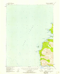
1953 Map of Seldovia B-6
USGS Topo · Published 1958About this map
Alexandrovsk sits on the lower Kenai Peninsula coast, reflecting the Russian influence that remained a defining characteristic of this region's settlement patterns into the mid-20th century. This 1953 survey documents the shoreline where Cook Inlet meets the mouth of Port Graham, capturing a landscape defined by maritime industry and resource extraction. A Coal Mine is located near Coal Cove in the north, while further south, small clusters of Piles and a lone Cabin suggest isolated coastal activity along the rocky inlets.
Find a feature on this map
22 named features on this map. Tap any name to fly to it.
Don’t see what you’re looking for? This feature index may not catch every label — zoom into the map to look around manually.
Map Details
Editions of this 1953 Seldovia B-6 Map
3 editions found
Other maps of this area

1946 · Seldovia C-5
USGS Topo · 1:63,360

1951 · Seldovia C-5
USGS Topo · 1:63,360

1951 · Seldovia
USGS Topo · 1:250,000

1951 · Seldovia B-5
USGS Topo · 1:63,360

1951 · Seldovia A-6
USGS Topo · 1:63,360

1951 · Seldovia B-6
USGS Topo · 1:63,360

1952 · Seldovia A-6
USGS Topo · 1:63,360

1953 · Seldovia B-6
USGS Topo · 1:63,360

1953 · Seldovia A-5
USGS Topo · 1:63,360

1953 · Seldovia B-5
USGS Topo · 1:63,360