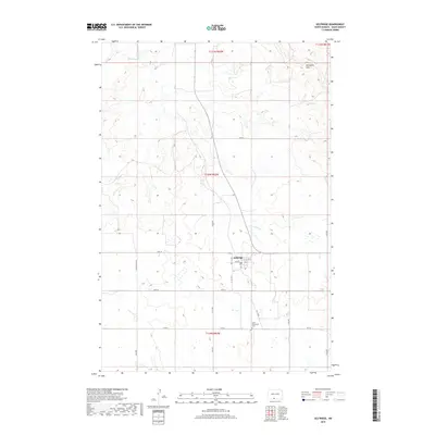
2018 Map of Selfridge
USGS Topo · Published 2018About this map
Selfridge serves as the primary hub of this Sioux County landscape, situated where Main St and 1st Ave N anchor the local townsite. The surrounding terrain is defined by the Porcupine Hills, with the meandering course of Porcupine Cr cutting through the northern and eastern sections of the quadrangle. A distinct grid of rural routes, including Section Line Rd and numerically named streets like 97th St, organizes the open prairie and provides access to outlying areas. This 2018 survey reveals a sparsely populated region where social and community markers are significant, notably the Saint Philomena Cem located south of the main settlement. The abundance of small wetlands and drainage patterns visible across the township lines indicates the vital relationship between the local geography and the seasonal water cycles of the Great Plains.
Find a feature on this map
22 named features on this map. Tap any name to fly to it.
Don’t see what you’re looking for? This feature index may not catch every label — zoom into the map to look around manually.
Map Details
Editions of this 2018 Selfridge Map
This is the sole edition of this map. No revisions or reprints were ever made.
Other maps of this area

1953 · McIntosh
USGS Topo · 1:250,000

1954 · Bismarck
USGS Topo · 1:250,000

1958 · Bismarck
USGS Topo · 1:250,000

1958 · McIntosh
USGS Topo · 1:250,000

1966 · McLaughlin NE
USGS Topo · 1:24,000

1971 · Barren Butte
USGS Topo · 1:24,000

1971 · Froelich Dam
USGS Topo · 1:24,000

1971 · Porcupine
USGS Topo · 1:24,000
1971 · Selfridge SE
USGS Topo · 1:24,000

1971 · Selfridge
USGS Topo · 1:24,000
Featured Places
- Fort Yates District, ND
- Selfridge, Porcupine District
- Porcupine District, ND
- Sioux County, ND
- United States