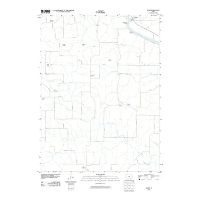
2010 Map of Selma
USGS Topo · Published 2010About this map
The Des Moines River cuts through the northeast corner of this Van Buren County landscape, where the settlement of Selma sits near the Selma Post Office and Shidepoke Access. This area is defined by a dense concentration of rural burial grounds, offering significant value for genealogical research. Named cemeteries such as Glasgow Cemetery, Bethlehem Cemetery, Heidlebaugh Cemetery, and Mount Gilead Cemetery are scattered across the township grid. To the south, the village of Troy and its accompanying Troy Cemetery mark the lower boundary of the survey. The terrain is deeply etched by a network of waterways including Chequest Creek and Holcomb Creek, which dictate the placement of local routes like Vetch Ave and Yam Blvd. The map also identifies smaller hamlets like White Elm and Chequest, reflecting the distributed settlement patterns of the early 21st century.
Find a feature on this map
69 named features on this map. Tap any name to fly to it.
Don’t see what you’re looking for? This feature index may not catch every label — zoom into the map to look around manually.
Map Details
Editions of this 2010 Selma Map
This is the sole edition of this map. No revisions or reprints were ever made.
Other maps of this area

1954 · Centerville
USGS Topo · 1:250,000

1956 · Agency
USGS Topo · 1:24,000

1956 · Ottumwa South
USGS Topo · 1:62,500

1957 · Centerville
USGS Topo · 1:250,000

1958 · Centerville
USGS Topo · 1:250,000
1965 · Eldon
USGS Topo · 1:24,000

1965 · Selma
USGS Topo · 1:24,000
1965 · Libertyville
USGS Topo · 1:24,000

1965 · Douds
USGS Topo · 1:24,000
1970 · Cantril
USGS Topo · 1:24,000