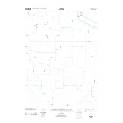
2013 Map of Selma
USGS Topo · Published 2013About this map
Selma sits along the northern banks of the Des Moines River, serving as a focal point for this section of Van Buren County. The landscape is defined by an intricate drainage system that feeds into the river, with Chequest Cr and its various tributaries, including S Chequest Cr and Locke Br, carving paths through the rural township. These waterways dictated the early placement of crossings and small settlements like White Elm and Chequest, which remain connected by a grid of local roads and trails such as Silver Trl and Varnish Trl. Public recreation is centered at the Shidepoke Access, providing entry to the river. The map illustrates a classic Iowan agricultural layout, where the natural course of streams like Holcomb Cr and Vesser Cr intersects with the straight lines of 21st-century county infrastructure.
Find a feature on this map
68 named features on this map. Tap any name to fly to it.
Don’t see what you’re looking for? This feature index may not catch every label — zoom into the map to look around manually.
Map Details
Editions of this 2013 Selma Map
This is the sole edition of this map. No revisions or reprints were ever made.
Other maps of this area

1954 · Centerville
USGS Topo · 1:250,000

1956 · Agency
USGS Topo · 1:24,000

1956 · Ottumwa South
USGS Topo · 1:62,500

1957 · Centerville
USGS Topo · 1:250,000

1958 · Centerville
USGS Topo · 1:250,000
1965 · Eldon
USGS Topo · 1:24,000

1965 · Selma
USGS Topo · 1:24,000
1965 · Libertyville
USGS Topo · 1:24,000

1965 · Douds
USGS Topo · 1:24,000
1970 · Cantril
USGS Topo · 1:24,000