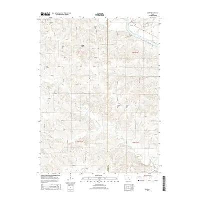
2015 Map of Selma
USGS Topo · Published 2015About this map
The Des Moines River cuts through the northeast corner of this landscape, anchoring the settlement of Selma. This section of Van Buren and Davis Counties is defined by its numerous small burial grounds and a dense network of waterways feeding into Chequest Creek. While larger towns like Troy and the crossroads at White Elm provide central points for the community, the map reveals a history preserved in small family and community plots such as Anderson Cem, Passmore Cem, and Heidlebaugh Cem.
Find a feature on this map
80 named features on this map. Tap any name to fly to it.
Don’t see what you’re looking for? This feature index may not catch every label — zoom into the map to look around manually.
Map Details
Editions of this 2015 Selma Map
This is the sole edition of this map. No revisions or reprints were ever made.
Other maps of this area

1954 · Centerville
USGS Topo · 1:250,000

1956 · Agency
USGS Topo · 1:24,000

1956 · Ottumwa South
USGS Topo · 1:62,500

1957 · Centerville
USGS Topo · 1:250,000

1958 · Centerville
USGS Topo · 1:250,000
1965 · Eldon
USGS Topo · 1:24,000

1965 · Selma
USGS Topo · 1:24,000
1965 · Libertyville
USGS Topo · 1:24,000

1965 · Douds
USGS Topo · 1:24,000
1970 · Cantril
USGS Topo · 1:24,000