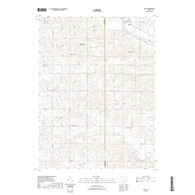
2018 Map of Selma
USGS Topo · Published 2018About this map
The Des Moines River cuts through the northeast corner of this landscape, anchoring the settlement of Selma at the junction of Stump Cr and the riverbanks. This area is defined by its rural cemetery network, which serves as a vital record of local family history and nineteenth-century pioneer lineages. From Bethlehem Cem in the northwest to Troy Cem near the southern border at Troy, these sites are often situated near the rolling breaks of seasonal waterways like Vesser Cr and Chequest Creek. The topography transitions from the river valley into a dissected plateau where small, dispersed settlements like White Elm persist along the section lines. The concentration of burial sites, including Passmore Cem and Mount Gilead Cem, suggests a long-standing community structure that has endured since the initial settlement era in Van Buren Co and Davis Co.
Find a feature on this map
84 named features on this map. Tap any name to fly to it.
Don’t see what you’re looking for? This feature index may not catch every label — zoom into the map to look around manually.
Map Details
Editions of this 2018 Selma Map
This is the sole edition of this map. No revisions or reprints were ever made.
Other maps of this area

1954 · Centerville
USGS Topo · 1:250,000

1956 · Agency
USGS Topo · 1:24,000

1956 · Ottumwa South
USGS Topo · 1:62,500

1957 · Centerville
USGS Topo · 1:250,000

1958 · Centerville
USGS Topo · 1:250,000
1965 · Eldon
USGS Topo · 1:24,000

1965 · Selma
USGS Topo · 1:24,000
1965 · Libertyville
USGS Topo · 1:24,000

1965 · Douds
USGS Topo · 1:24,000
1970 · Cantril
USGS Topo · 1:24,000