
1961 Map of Selma
USGS Topo · Published 1963About this map
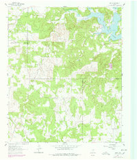
Selma sits at the junction of several county lines in the early 1960s, serving as a focal point for this rural North Texas landscape. The northeastern portion of the sheet is dominated by the sprawling waters of Lake Amon G Carter, where the terrain drops to meet the reservoir's controlled inundation levels. Evidence of the region's energy economy is clear through the presence of the Bowie SW Oil Field and various Oil Well symbols scattered across the hills. Numerous watercourses, including Big Sandy Creek, Cottonwood Creek, and Venchoner Creek, carve through the wooded topography. Local history is anchored by the Selma Cem and Crafton Cem, while several county boundaries converge in the west and south, including a rare tri-point where Clay, Jack, and Montague Counties meet. This era is further defined by the infrastructure of a prominent Pipeline cutting across the northwestern quadrant.
Find a feature on this map
19 named features on this map. Tap any name to fly to it.
Don’t see what you’re looking for? This feature index may not catch every label — zoom into the map to look around manually.
Map Details
Editions of this 1961 Selma Map
2 editions found
Other maps of this area

1905 · Montague
USGS Topo · 1:125,000

1954 · Sherman
USGS Topo · 1:250,000

1954 · Wichita Falls
USGS Topo · 1:250,000

1958 · Wichita Falls
USGS Topo · 1:250,000

1958 · Sherman
USGS Topo · 1:250,000

1961 · Brushy Mound
USGS Topo · 1:24,000

1961 · Sunset
USGS Topo · 1:24,000

1961 · Bowie
USGS Topo · 1:24,000

1961 · Crafton
USGS Topo · 1:24,000
1961 · Chico
USGS Topo · 1:24,000