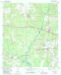
1978 Map of Seminole
USGS Topo · Published 1987About this map
The Perdido River and the Styx River define this Gulf Coast borderland, where the winding water separates Baldwin Co and Escambia Co and the states of Alabama and Florida. The landscape is marked by a legacy of resource extraction, with numerous claypits and claypit operations dotting the terrain between Bellefontaine Cr and Spring Branch. Transportation and infrastructure are central themes, seen in the Old Railroad Grade running through the bottomlands near Seminole and the expansive U S Naval Reservation dominating the eastern edge of the survey.
Find a feature on this map
38 named features on this map. Tap any name to fly to it.
Don’t see what you’re looking for? This feature index may not catch every label — zoom into the map to look around manually.
Map Details
Editions of this 1978 Seminole Map
3 editions found
Other maps of this area

1920 · Robertsdale
USGS Topo · 1:62,500

1921 · Bon Secour
USGS Topo · 1:62,500

1921 · Fort Barrancas
USGS Topo · 1:62,500

1921 · Muscogee
USGS Topo · 1:62,500

1941 · Fort Barrancas
USGS Topo · 1:62,500

1941 · Muscogee
USGS Topo · 1:62,500

1941 · Robertsdale
USGS Topo · 1:62,500

1941 · Foley
USGS Topo · 1:62,500

1943 · Robertsdale
USGS Topo · 1:62,500

1943 · Muscogee
USGS Topo · 1:62,500